Beacon Hill, Penrith
22nd February 2026
FINAL DETAIL (16/2/26)
Any changes after this date will be highlighted here
A downloadable version of the final details is available HERE but it won’t contain any last minute changes.
Border Liners are delighted to welcome LOC, MDOC, SROC, WCOC, PFO, SELOC and SOLWAY to Beacon Hill, a small but lovely area of varied woodland on the north side of Penrith.
Parking
There is no event car park. Competitors should park either in one the public car parks in Penrith or find suitable street parking. A map showing the three most suitable car parks is here. All the car parks charge £1.30 for the full day on Sundays. Payment is by coins or the PayByPhone app.
The only car park suitable for coaches is Sandgate.
Event Centre
The Event Centre is at 2nd Penrith Scout Hut, 17 Folly Lane
Postcode CA11 8BT
what3words ///eggplants.hormones.mammals
Grid Ref: NY 518 301
We also have use of the nearby Army Cadet Hall. To get between the two buildings you need to go round the road (pink line on map below)
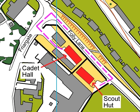
The following will be located at the Scout Hut:
– Enquiries
– Download
– Entry on the day for Non-CompassSport Cup courses
– SI Card Hire
– Toilets (2 portaloos and 2 inside the building)
– Key Drop
– Space for club tents (unless the grass is very wet), but you may prefer to use the indoor space at the Cadet Hall
The following will be located at the Cadet Hall:
– Indoor space for clubs to set up camp and leave kit
– Toilets (2 inside the building)
– Refreshments – Binsey Field Kitchen will serve hot burrito bowls and a selection of yummy cakes and tray bakes as well as coffee and smoothies
Please don’t wear muddy shoes or shoes with metal dobbs (even if clean) in either building.
Important: Unfortunately dogs are not permitted in the Cadet Hall or its grounds. However they are allowed in the Scout Hut and its grounds. Competitors are encouraged to use the Cadet Hall for leaving kit and socialising, but anyone with a dog can use the Scout Hut instead.
Non-Compass Sport Cup Courses – Entry on the Day, Shadowing, Maps, Insurance
Limited entry on the day is available on the Non Compass Sport Cup courses. The cost is £13 for seniors (21+), £5 for Juniors (20-) and full-time students. Registration is in the Scout Hut. You will not be allocated a start time – just go to the start when you are ready. SI card hire is available free (but £30 if you lose it). To secure a map, contact the organiser (see below) by Friday 20th Feb.
Competitors on the Non-Compass Sport courses can compete in pairs or as a group, or be shadowed. Shadowers of those on Non-CSC courses, if competing in the CSC themselves, must have completed their CSC course before shadowing.
Extra maps for groups or shadowers available at £1 each.
There will be copies of the White and Yellow courses at Registration for competitors to look at in advance. It will also be possible to look at the maps in the pre-start area – just ask a start official.
Note: if you are not a member of British Orienteering please read the important note regarding public liability insurance here.
Location of Start, Finish and Clothing Dump
The Start is 1.9 km with 120 m ascent from the event centre. It’s mostly on roads and a tarmaced path but the last 150m is on a narrow woodland track.
From the Finish it is 1.2 km back to the event centre, all downhill.
There is a Clothing Dump (manned) about 50m off the route to the start and on the way back from the finish
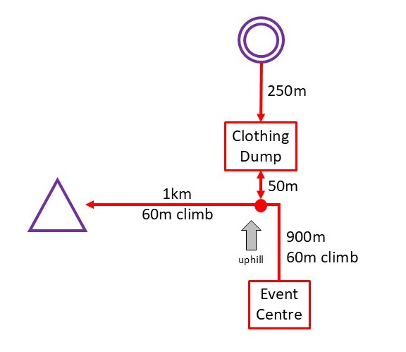
The routes from the Event Centre to the Start and back from the Finish to the Event Centre (where download is located) will be taped.
If you do not intend to visit the Event Centre before running then you should make your own way to the point where the routes to the Start and Finish split (near the Clothing Dump) and follow tapes from there. This point is about 40m west of the junction of Fell Lane and Beacon Edge (GR NY 521 309, what3words: ///pancakes.modern.hothouse, Postcode: CA11 7SD)
Start Details
Start times are 10:30 to 12:30. Your Club Captain will be able to tell you what your start time is. A start list will be available here a few days before the event (but it will not include any changes made after 17th Feb). Final start lists will be on display at the Event Centre and Pre-Start
If you are late, the start officials will be able to fit you in but there might be a significant wait for a space.
Those on non-Compass Sport Cup courses have not been allocated start times – just turn up at the Start when you are ready to run.
It is a punching start, and the start kite (i.e the triangle on the map) is located about 150m from the map issue point. The route will be taped and shown on the map (as specified in ISOM2017). You MUST go to the start kite, even if you think you can see a better route to your first control. This is a British Orienteering rule, and will be enforced.
Loose descriptions will be available in the start lanes.
Unfortunately there is not much space for warming-up in the pre-start area.
There are no toilets at the start.
Finish, Download and Course Closing Time
It is a punching Finish. Download is at the Event Centre (in the Scout Hut). Please don’t forget to download, even if you retire
Courses will close at 14:30. Please make sure you download (at the Event Centre) by 14:45.
Map
1:7500 or 1:5000 depending on course (see table below), 5m contours.
Re-surveyed autumn 2025 with LiDAR data by Martin Bagness.
An old version of the map can be seen here. Copies of the new map will be on display at the Event Centre and in the start lanes
There is one non-standard (ISOM 2017 symbol):

The green vertical stripe symbols (ISOM no. 407 and no. 409) can represent low rhododendrons, significant brashings and areas with multiple fallen trees
The dark green “fight” symbol (ISOM no. 410) can represent large rhododendrons, dense conifers and windblown.
The steep slope on the south edge of the area is popular with (non-permitted) mountain bikes. On the whole, mountain bike tracks are shown, but as they can quite literally, appear overnight, be prepared for unmapped ones.
Control circles are 7.5 mm diameter on the 1:7500 maps, scaled up to 11.25 mm on the 1:5000 maps.
Control Descriptions
These will be available loose in the start lanes and also printed on the front of the map. White and Yellow courses have text descriptions. All other courses have pictorial descriptions.
Terrain
Beacon Hill is a well thinned pine woodland, with a steep slope on the south side, and gentler slopes to the west and north-east. On the flattish top area there is heather and bilberry underfoot. Elsewhere there is some bracken, but in February the majority of it will be well flattened. The area includes many old sandstone quarries creating interesting contour features and crags. There is a good path network, and also numerous mountain bike tracks on the steep south side. The high point is crowned by the eponymous Beacon, a Grade 1 listed sandstone tower built in 1719 as a place to light warning fires.
There has been a lot of Forestry work over the last few months. There is evidence in the form of brashings, tree stumps, muddy vehicle routes and log piles in many places.

Courses
CompassSport Cup/Trophy Courses
| Course Number | Age Categories | Map Scale | Length | Climb |
| 1 * | Any competitor | 1:7500 | 6.9 km | 125 m |
| 2 | M18-, M45+ | 1:7500 | 5.2 km | 110 m |
| 3 | Any woman | 1:7500 | 5.2 km | 120 m |
| 4 | M55+ | 1:7500 | 4.4 km | 100 m |
| 5 | W18-, W45+ | 1:7500 | 3.5 km | 95 m |
| 6 | M65+ | 1:5000 | 3.7 km | 100 m |
| 7 | M75+, W60+ | 1:5000 | 3.1 km | 50 m |
| 8 | M80+, W70+ | 1:5000 | 2.6 km | 50 m |
| 9M and 9W | M18-, W18- | 1:7500 | 3.6 km | 70 m |
| 10M and 10W | M14-, W14- | 1:7500 | 2.2 km | 50 m |
Notes:
* Course 1 has a double-sided map with a map-flip
Non-CompassSport Cup/Trophy Courses
| Name | Technical Difficulty | Map Scale | Length | Climb |
| Light Green | 4 | 1:7500 | 3.3 km | 50 m |
| Yellow ** | 2 | 1:7500 | 3.1 km | 45 m |
| White *** | 1 | 1:7500 | 1.8 km | 35 m |
Notes from Planner and Controller:
*** White uses only main tracks. Numerous mountain bike trails cross the main tracks – too many to have a control on each junction. However, smiley and frowning face signs will keep competitors on track. The map shows a patch of dark green across the path just before one control. This represented a fallen tree which has very recently been cleared. The control will be very visible so there will be no problem. (Also affects Yellow.)
** Yellow is longer than average, and possibly slightly harder (but still TD 2). Also see note about the fallen tree on White.
Controls
Controls will be enabled for contactless punching for those with SIAC cards. The start and finish will need to be punched manually. All controls have a pin-punch attached. If an SI box fails (ie. you don’t hear a beep) then you should punch your map instead.
Results
Results will be available on-line during the event at: https://www.sportident.co.uk/results/BL/2026/PenrithBeaconCSC2026/
There will be a QR code on splits printouts.
Safety
Full body cover is required. Whistles are strongly recommended. The steep southern slope can be slippery so wear shoes with good studs.
It is possible, but unlikely, that wearing or carrying a cagoule will be compulsory. There will be notices at the Event Centre and Clothing Dump to let you know.
Some courses, including White and Yellow, pass close to the top of a big crag (10m high at least). It will be marked with black and yellow hazard tapes.
The run in from the last control to the finish is on flat ground but is narrower than many run-in areas: people should look to avoid collisions with slower moving competitors.
Some routes descending to the last control are on narrow, reasonably steep mountain bike trails. Overtaking will be difficult and if attempted should not involve jostling other competitors.
There are a number of log piles in the area, adjacent to paths. It is extremely dangerous to climb on these.
There will be non-orienteers in the area including children and dog-walkers. Please be courteous. There may also be mountain bikers – watch and listen out, especially on the steep slope where they won’t be able to stop.
First Aid etc.
First Aid will be available at the Event Centre (Scout Hut) and there will also be a first aid kit at the clothing dump.
Anyone with existing medical conditions is welcome to leave appropriate information at Registration, in a sealed envelope that will only be opened in an emergency. Uncollected envelopes will be shredded after the event
The nearest hospitals are:
Minor Injuries Unit at Penrith Community Hospital CA11 8HX, what3words: ///insulated.fencing.servers. (about 1km from Event Centre)
Full A&E at Cumberland Infirmary in Carlisle CA2 7HY, what3words: ///cool.pines.tribune (about 35km miles from Event Centre)
The nearest defibrillator to the Event Centre is in a former telephone box on Sandgate, about 300m from the Event Centre (what3words: ///every.stag.budding)
Dogs
Dogs will be allowed, on leads, both inside the Scout Hut and in the grounds. They are definitely NOT allowed in the Army Cadet building or its grounds. No dogs on courses please.
Cancellation
If the event has to be cancelled for any reason, significant snow or wind being the most likely, a notice will appear on the BL home page (https://borderlinersorienteering.org/ ). Club Captains will be informed by email and should pass the information on to their team. If the event is cancelled, it is unlikely to be re-arranged and there will be a partial refund of entry fees.
Officials
Planner: Andrew Bell, BL
Organiser: Karen Parker, BL (contact via email BLDanAndKaren@gmail.com)
Controller: Tim O’Donoghue, SOLWAY
Thanks
2nd Penrith Scouts for use of their Scout Hut
The Reserve Forces’ & Cadets’ Association for the use of the Cadet Building
Lonsdale Estates and Lowther Estates Trust for permission to use Beacon Hill
