FINAL DETAILS
V1: Issued 13th May
V2: 14th May – bin bag for empty bottles at start. EOD registration times. Yellow includes taped route
Part of the Northern Champs Weekend in association with MDOC


Location/Parking
Parking is in a field at Butterwick, on the west side of the minor road between Askham and Bampton. It is about 15 minutes drive from either junction 39 or junction 40 of the M6. The only road signs will be where you turn into the field. Parking fee is £2 per vehicle.
Grid Ref: NY510197
W3W: chitchat.ports.bloomers
Postcode: CA10 2QQ
Large Vehicle Parking
The entrance to the field is 4 metres wide and a bit bumpy. If you are coming in a large campervan or minibus and would prefer to park elsewhere, hard-standing and smooth grass are available at Bampton Memorial Hall about 2km south of the parking field. There will be an orienteering kite at the entrance but no other road signs. Parking fee is £2 per vehicle. See here for details of distances to start, finish, and event centre/download.
Grid Ref: NY516181
W3W: trickster.starts.dial
Postcode: CA10 2RS
Event Centre
The Event Centre is at the south end of the parking field. Here you will find:
Enquiries
Registration (for anyone entering on the day) (10:30 to 13:00)
SI-Card collection (for hire cards)
Key drop
Portable Toilets (note that there is also a toilet close to the start)
Download
Results Display
String Course
Traders – Compass Point, Podium Catering, L’al Yan Coffee Van
First Aid (at Download)
Terrain
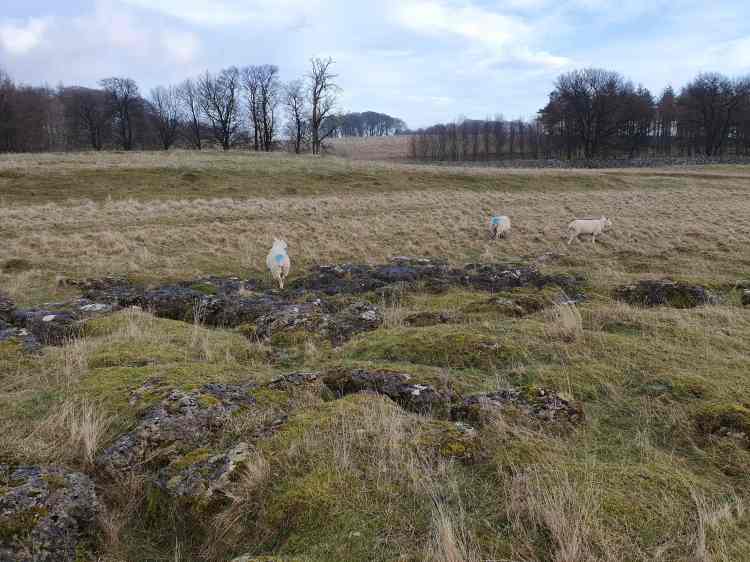
Knipe Scar is a limestone escarpment. The top is fairly flat with areas of limestone pavement and a stone circle. To the west is a moderately steep slope with areas of old mine working giving interesting contour and rock detail. On the lowest slopes there are many gorse thickets which have been accurately mapped and require careful navigation. Generally the going is very fast, though some of the more complex areas have dead bracken to slow you down. New bracken has started to grow but shouldn’t significantly impede progress. There are occasional, avoidable, nettle patches. Take care on the upper slopes where limestone pavement and scattered limestone blocks are a challenge for ankles.
The map from a previous event can be seen on Routegadget here (but note that rough open is now shown in white not 50% yellow)

Courses
This is a middle distance event.
| Course | Length and climb | UKOL Classes (Men) | UKOL Classes (Women) |
| Black ** | 6.2km, 265m | M18, M20, M21, M35, M40 | |
| Brown ** | 5.2km, 180m | M16, M45, M50, M55 | W21 |
| Blue | 4.5km, 165m | M60 | W16, W18, W20, W35, W40, W45 |
| Green | 3.7km, 155m | M65, M70 | W50, W55 |
| Short Green | 3.1km, 125m | M75 | W60, W65 |
| Very Short Green | 2.5km, 60m | M80, M85, M90, M95, | W70, W75, W80, W85, W90, W95 |
| Light Green | 2.6km, 115m | M14 | W14 |
| Orange | 2.4km, 55m | M12 | W12 |
| Yellow ## | 1.8km, 50m | M10 | W10 |
** Black and Brown courses have a map flip. Control descriptions are split over the two sides.
## Yellow course map will be available to view at Registration. The Yellow course includes a taped route between two controls.
String Course
There will be a string course adjacent to the car park. Enter on the day. No charge
Entries
Pre-entry for all courses is now closed.
Late entry still available on all courses. Contact bldanandkaren@gmail.com with your details and which course you want to run. (Senior £11.00, Junior/Student £5.00 – you will be asked to pay by bank transfer in advance)
Entry on the day will only be available for Yellow, Orange and Light Green courses (Senior £11.00, Junior/Student: £5.00). Spare maps for anyone wanting to go round as a pair or group will be available for £1.00. Registration open 10:30 to 13:00.
SI Card (Dibber) hire
If you ordered a hire SI Card when entering, collect it from Registration on the day. Hire cards are also available to anyone entering on the day. There is no charge but lost cards will incur a charge of £30.
Start Times
11.00 to 14.00.
Start times are available here. If your start time is given as “open” it means that you can go to the start whenever you want and the Late Start Marshal will find a gap for you. If you entered after the closing date you do not appear on the start list, and you have been given an open start.
Any one entering on the day will also have an open start.
Start
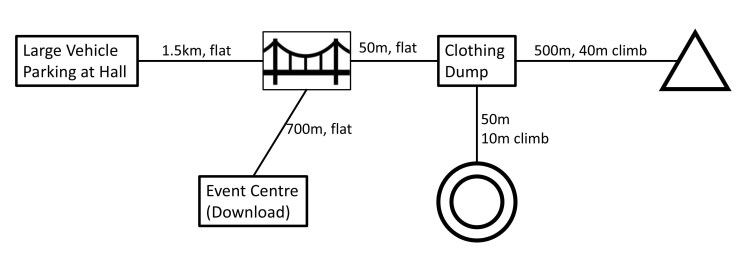
The Start is 1.3 km with 40m climb from the event centre/parking field. Follow signs from the gate at the south east corner of the car park (by the Download tent). After about 750m you reach the Clothing Dump (which is very close to the Finish).
For those in large vehicles parked at Bampton Memorial Hall see here
NOTE: The route to the start include crossing a suspension bridge over the River Lowther. The bridge has fenced sides, and it’s impossible to fall off, but if anyone would prefer not to use it they can either ford the river (25cm deep just downstream from the bridge) or ask at Enquiries about an alternative route (adds about 2.6 km distance)
There is a portable toilet on the road very close to the start.
Call up is at -4 minutes. If you are late for your start, or have not been allocated a start time talk to the Late Start Marshal who will fit you in. Please don’t ask to start early unless you really need to.
It is a punching start. There is a 170 m taped run-out from map pickup to the Start Kite (i.e. to where the start triangle is shown on the map)
Loose descriptions will be available in the start lanes. Map boxes and descriptions will be labelled with course colour, not UKOL age class so you need to know what course you are doing. It’s your responsibility to pick up-the correct map – be particularly careful if you are doing one of the FOUR varieties of green course.
There will be a bin bag for empty bottles in case anyone wants to take water to the start.
Finish
From the Finish it is about 0.8 km flat walk climb back to the event centre/parking.
Courses close at 15.30. The Finish SI-Box will not be SIAC-enabled.
Clothing Dump
There is an area where you can leave clothing or anything else (bottles of water perhaps) adjacent to the finish, and on the route to the start. It will not be manned.
Clothing
Shorts are permitted, but you may encounter gorse and very sharp bits of dead bracken. You are advised to carry a whistle.
In the very unlikely case that the weather is very wet and/or windy cagoules and full leg cover could be compulsory
Hot, sunny weather is far more probable so consider head protection and sun cream too.
Map
1:7,500, 5m contours for all courses.
Rough open is shown as white rather than the conventional 50% yellow.
Fields, outside the fell wall are shown in 100% yellow and should be regarded as out of bounds.
There are very few trees on the area; all are small in size and are not mapped.
Symbols are ISOM 2017-2 except for:
Control Descriptions
These are available loose in the start lane, and are also printed in black on the front of the map (or the appropriate side of the map for Black and Brown which have a map flip)
Yellow Course has text descriptions.
Orange Course has both text and pictorial descriptions
All other courses have pictorial descriptions
Road Crossings
All courses cross a minor road with very little traffic. However visibility for both vehicle drivers and runners can be limited due to gorse along the road edge so please exercise caution before jumping out into the road. The road crossing for Yellow and Orange courses will be manned.
Dogs
Dogs are permitted on leads in the car park, but no dogs on courses please.
Results
Results and Routegadget will be available here after the event.
Safety
A comprehensive risk assessment has been carried out, but competitors take part at their own risk and are responsible for their own safety during the event.
Other members of the public, including dog walkers and farmers may be in the competition area. Please be considerate.
There are sheep and deer in the competition area so please check for ticks after the event.
Competitors with an existing medical condition are invited to leave details in a sealed envelope at enquiries (and collect it after finishing)
Information for those parking at Bampton Memorial Hall (Larger Vehicles)
The distance to the start is 2.1km and 40m climb
The distance to/from the event centre is 2.2km, flat
The first part of these two routes (1.5km), as far as the suspension bridge, is common. At this point you turn right over the suspension bridge to reach the start (a further 600m) or continue straight on to the event centre (a further 700m). The finish and clothing dump are just over the suspension bridge.
After finishing you must go to the event centre to download before returning to the hall.
All the routes will be signed from the hall gateway.
Toilets are available in the main hall building
Officials
Planner: Keith Tonkin (BL)
Organiser: Karen Parker (BL) – bldanandkaren@gmail.com
Controller: Nick Evans (WCOC)
British Orienteering AGM
The AGM will be held at 4pm at Bampton Memorial Hall which is about 2.0km drive from the parking field (and where larger vehicles are parking). Details available here. If you go to the AGM please park there rather than leaving your vehicle in the parking field.
Other Orienteering Opportunities
For anyone staying in the Lake District between the British Champs Weekend and the Northern Champs Weekend, Border Liners are putting on a “Penrith Explorer” MapRun Event in Penrith, between now and 16th May.
Also check the WCOC website for the events that week (Thursday 15th – High Rigg Fell, 4 miles SE of Keswick, Friday 16th – Keswick Urban Sprint)
For information about data privacy, safeguarding and insurance please see the BL website https://borderlinersorienteering.org/
