Saturday 21st November 2026
FINAL DETAILS
(Updated 19/11/2026)
IMPORTANT – Preliminary Event Details gave the date as SUNDAY 21st Nov. It should be SATURDAY 21st Nov. Apologies for the confusion
Location
Gelt Woods is 2km south of Brampton and 12km east of Carlisle
Parking
GR NY 524 597,
W3W ///trunk.ending. grief
This at the top of a dead end road.
Look out for O-signs from the A69 signposted Hayton/Town Head. After 200 metres turn sharp left over the bridge and continue to the top of the road.
Parking will be linear. There is room to turn around at the top.
Enquiries, Download, and a Portaloo are at the top (north-east end) of the parking. If you have ordered a dibber, collect it from Enquiries
Entries
Pre-entry now closed. Entry List available here.
There will be some entry-on-the day on Yellow course only (subject to map availability) .
Seniors (21 and over): £8
Juniors (20 and under) and full-time Students: £3
If you are new to orienteering and would like to go round as a group or in a pair, just enter one person and purchase any additional maps that your group would like at £1 each.
Dibber hire available at no charge, £30 if not returned.
Coaching
There is a coaching session, open to all, from 10:00 to 11:00.
If you pre-booked coaching when entering, the coach will contact you in advance with details.
If you would like to attend but have not pre-booked, please contact the organiser in advance (aclewsley@gmail.com). There is no charge.
Start and Finish
It is a 700m downhill walk to the start and the same back up from the finish.
The route is along the road cars are driving in on so drivers and competitors please take care.
Note: The start and finish are based at a small car park which is the main access point for the public using Gelt Woods, and it can get very busy. Parents of small children bear this in mind in terms of safeguarding.
Starts from: 11.00 – 12.30
Courses Close: 14.00
Important: the area is popular with dog walkers and other members of the public, please be courteous to them.
Terrain
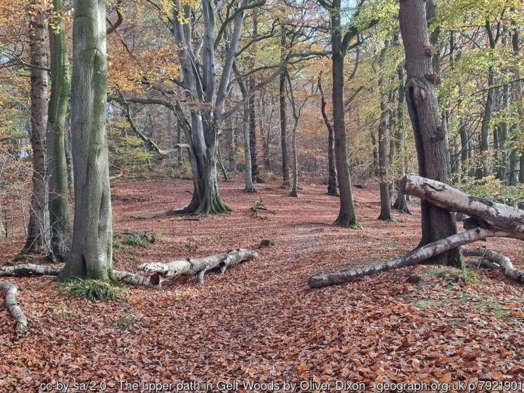
Gelt Woods is a mixed woodland. It is generally runnable but has some steep slopes and big crags, which should be avoided. There is also a small area of rough open some of it marshy. At this time of year much of the area is covered by leaf litter which can be slippy (especially in wet or icy weather), hide trip hazards, and make some paths indistinct.
Note 1: Several trees came down in the recent storm, one of which blocked a main access route in the wood. It has been cleared but the timber is piled up by the side of the path. Please avoid any contact with these logs.
Note 2: Another fallen tree on a path which everyone will use has not been removed. It is easy to get past either through the middle (taped), or on the upslope of the tree.
The small open green circle on the map represents a distinct Holly tree/bush. Where these are used as Control sites it is shown as a distinct single tree on the control descriptions
Map
1:7500 5m A4 2020 survey based on LIDAR data. Map from a previous event can be seen here
Courses
Unfortunately it has not been possible to plan an Orange due to the nature of the terrain.
PLEASE NOTE :
All courses have a map flip including Yellow
| Course | Distance (km) | Climb (m) | Controls | Ideally suited for… |
| Blue | 5.1 | 300 | 29 | Experienced orienteers wanting the highest level of navigational and physical challenge |
| Green | 3.7 | 155 | 21 | As above but shorter |
| Short Green | 2.4 | 100 | 17 | Experienced orienteers wanting the highest level navigational challenge, but with less physical demand |
| Very Short Green | 1.7 | 75 | 12 | As above but shorter |
| Yellow | 1.7 | 35 | 15 | Newcomers, children and families – great for building experience and learning skills |
Punching
SI with SIAC enabled; you still need to punch the start and the finish
Control Descriptions
These are on the map – there are no loose copies
Dogs
Sorry, no dogs are allowed on courses.
Safety
- A comprehensive risk assessment has been carried out by the organiser, but please remember that competitors take part at their own risk. Orienteering is an adventure sport – your safety is your own responsibility.
- Please make sure you download even if you do not complete your course.
First Aid
A first aid sack will be located at the finish on a do it your-self basis. There will be a first-aider at download.
Nearest Hospital
Cumberland Infirmary, Newtown Road, Carlisle, Cumbria CA2 7HY (Tel 01228 523444)
Grid reference NY387561
What 3 words: ///cool.pines.tribune
Officials
Organiser: Stella Lewsley
Planner: Andrew Lewsley
Enquiries to aclewsley@gmail.com
Note about Insurance
If you are not a member of British Orienteering please read the important note regarding public liability insurance here
Border Liners Data Privacy, Photography and Safeguarding policies
Available here and here

