31/10/2024 – Final details published
Parking: Keswick Golf Club, Threlkeld Hall, Threlkeld, Keswick, CA12 4SX.
Final Details
Brand new area, mapped by Keith Tonkin (BL) and with special thanks to Tony Duncan (Keswick Golf Club, and WCOC) for supporting our request to map and use the area.
First event of the 2024/25 North West Night League.
Fast, open running, with stands of mature and younger woodland, and a scattering of interesting contour features. A perfect first night event, or warm up for the winter night orienteering season.
Parking
Keswick Golf Club, Threlkeld Hall, Threlkeld, Keswick, CA12 4SX. Please follow any instructions upon arrival.
Toilets
A portaloo will be available adjacent to the parking.
Registration, SI-card borrowing and download
Registration will be adjacent to parking. If you have pre-entered, you may go directly to the start. If you are entering on the day, and/or wish to borrow at SI-card please visit registration before you go to the start. Please ensure you download before you leave the site, even if you did not complete your course.
First Aid/Medical
At registration and download. The risk assessment will be held at registration/download.
Entries: Online entries have closed. Entry on the day is available for the Orange course only. Entry on the day payment by cash and if you can bring the correct change, that will help us.
Adults £9
Junior/Student £3
Starts Times 1800-1900
Courses close 2045
Start
Start is an 150m walk from the parking.
Finish
Finish is a 200m walk back to download. While all controls on the courses will be SIAC enabled for contactless punching, you will need to punch the finish control.
Whistles and Clothing
It is strongly recommended that competitors carry a whistle. The event is in November and on an open area. In wind and/or rain, competitors are strongly advised to wear a waterproof jacket and other clothing appropriate to the weather on the day. The fairways in particular can hold a lot of water on smooth grass, which can be slippery. Shoes with studs are very strongly recommended.
Courses
| Distance | Climb | Controls | Map flip | Notes | |
| Blue | 5.9km | 130m | 24 | Yes | Some controls visited twice |
| Green | 4.3km | 95m | 19 | Yes | No |
| Orange | 2.6km | 75m | 14 | No | No |
Map
A brand new area, mapped by Keith Tonkin and with special thanks to Keswick Golf Club for permission to use the area. The map is A4 in size at a scale of 1:5000 with 2.5m contours. Control descriptions on front of map. No loose control descriptions.
Terrain notes from the mapper
- Keswick Golf Course is on the lower slopes of Threlkeld Common with the Glenderamackin river on its north side and bisected by the long-disused Penrith to Cockermouth railway line. It suffers from poor drainage; fairways in many places are frequently soft to very soft underfoot and there are many ditches alongside and sometimes within the fairways.
- Fairways, the short grass playable surfaces, are mapped as open fields (bright yellow) and these will be fast-going.
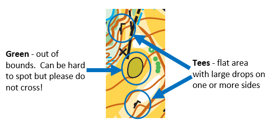
- Greens are marked with the Out of Bounds olive colour and a black line surround – you must not cross these. Courses are planned so that the optimum route should not cross greens. If you are not sure about the Out of Bounds olive green mapping colour, please ask at registration before you set out so we can show you what to avoid.
- On the sides, and sometimes the middle, of the fairways there are copses of trees and of course “rough”. The rough is mapped as mid-yellow rough open; adjacent to the fairways this is mostly long grass and is easy to get through, between fairways and in places where golfers generally don’t stray the grass is both taller and filled with thistles and other rough vegetation which may make progress a little slower, particularly for those who are less nimble.
- In creating the golf course and digging the streams and ditches to assist with drainage, numerous boulders have been dug up. These are mapped except where 1) they are used as tee markers, and 2) alongside one major track and part of the old railway line where they are boundary edges and would be too difficult to map sensibly.
- There are several ponds on the map; those marked with a black line around them should not be entered under any circumstances. You may prefer not to enter the other ponds either!
- Ditches vary in size from those you can easily step over (a spade width and depth – these small ones are not all mapped) to a few that are difficult to jump. Those in the latter category are mapped using the gully symbol rather than a blue dashed ditch but they are very likely still wet in the bottom. New ditch digging has been noticed recently; the map was updated 10 days prior to the event, but it’s still possible new ditches will appear.
- There are areas on the map of newer tree planting which are mapped with ‘walk’ screen. These areas are extremely slow going and are not recommended as a route choice.
- Benches are mapped with X.
Safety
There are a number of tees which are built up with stone walls on one or more sides. Please plan your route to avoid running over tees and then you won’t have to worry about this. However note that there is one tee in particular with a drop of around 2m off one side; which Green and Blue may pass early on their courses. This will be marked with tape.
Organiser and controller: Jeff Powell Davies entries@borderlinersorienteering.org
Planner: Isabel Berry
