30/03/2023 – Final Details
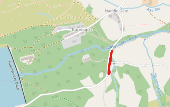
Parking: in field CA10 2RL
Grid reference NY511164
What 3 words ///regrowth.bridges.corporate
Terrain: Classic open Lakeland fell, situated to the north of Haweswater. Open runnable terrain with usual features of grassland, marshes, crags and intricate contour detail. A map from a previous event can be found on Routegadget here.
Car Parking: In farm field on right before Naddle Gate village. £2 per vehicle. Please have change.
Please note owing to heavy rainfall in the week we are unable to allow any large van/campervans/minibuses into the parking field. There is space to park such vehicles a little further on through Naddle Gate village, see marked area on map below. Please be careful on the road for passing traffic when returning to the parking field as there is only one entrance.
Directions: If approaching from the North. From Jct 40 M6 follow the A66 east to Kemplay Bank roundabout, follow signs for Eamont Bridge. Travel through Eamont Bridge, turn right at the roundabout by The Crown pub. Follow the B5320, cross over the train line and take the left at Yanwath Primary School to Askham village. Drive through Askham village continuing down the valley to Bampton, please note road does narrow, with a few blind corners and can be heavy with farm vehicles and cyclists. Take care! From Bampton village turn right over the bridge at the Village store signed for Haweswater and Mardale, there will be a sign on the bridge to direct. Follow for roughly 2km parking is on the right.
If approaching from the south, take Jct 39 M6 follow signs to Shap. Travel through Shap at the end of the village take the left after Iverson Garage signed Bampton and Haweswater. Follow the road for 6km to Bampton Garage, pass through the village over the River Lowther and follow the road right to Bampton village. From Bampton village turn left over the bridge at Village store signed for Haweswater and Mardale, there will be a sign on the bridge to direct. Follow for roughly 2km parking is on the right.
If approaching from Kendal, follow A6 to Shap and then directions as per south route.
Toilets: In car park
Start: 10:30 – 12:30
Walk to the start 850m/15mins 80m of climb, after 700m you will pass very close to the finish. Clothing can be left here at your own risk. When near to the finish please be mindful of any fast finishing runners.
Finish: Courses close at 14:30. Please ensure you have made it back to download. Early finishers may encounter people passing to the start, please be mindful if finishing quickly.
Entry on the day: for the Yellow/Orange courses only subject to map availability (£3.00 – extra maps £1.00) Yellow maps to be collected from the start. Copies will be available at download should anyone wish to have a look at the course in advance.
Maps: 1:10000 for Brown and Blue, 1:7500 for all other courses.
Brown and Blue have double sided maps – part 1 one side, part 2 on the reverse.
The map has very recently been fully resurveyed using LiDAR data. Open fell is shown in white rather than the standard 50% yellow. Fields are 100% yellow. Be prepared for unmapped quad bike tracks and sheep trods.
Yellow course: In a few short sections the paths could be a bit indistinct on the ground. There will tapes on canes to aid confidence.
Control Descriptions: Loose in start lanes and on the maps
Timing: Sportident – Controls will be SIAC Enabled. You will need to punch the Start and Finish.
Dibber Hire: Free but £30 payable if lost.
SAFETY
- When deciding what to wear you need to be mindful that this is an exposed, often windy area. Full leg covering is strongly advised in the event of wet weather.
- Whistles are compulsory – BE PREPARED FOR CAGOULES TO BE MADE COMPULSORY – this decision will be made on the day (it is Cumbria afterall) All competitors will be informed as they arrive.
- There are cliffs and crags on the area, some in depressions; the rock can be very slippery when wet.
- There are some grazing animals, mainly sheep but also some horses, however they are relatively docile.
- Safety bearing is due south, you should be able to encounter a path that leads back east towards the start area.
- Other members of the public may be in the competition area please be mindful of both their and your presence.
Dogs on lead in Car Park – no dogs on the course
Courses:
Brown 9.1km, 380m climb
Blue 6.2km, 260m
Green 4.1km, 200m
Short Green 3.0km, 120m
Very Short Green 2.3km, 80m ***SEE BELOW
Light Green 3.2km, 110m
Orange 2.7km, 80m
Yellow 2.0km, 65m
***VERY SHORT GREEN – this is the same course as the Short Green but with some controls missed out towards the end. If you want to do Very Short Green, pick up a Short Green map at the start. The map will show which controls to miss. You can decide while on the course whether or not to take the Very Short Green cut-off. The download system will work out which course you have done.
COURSES CLOSE AT 2.30PM. PLEASE REFPORT TO DOWNLOAD IN THE EVENT FIELD EVEN IF YOU DO NOT COMPLETE YOUR COURSE
Nearest A & E
Cumberland Infirmary
Newtown Road
Carlisle
CA2 7HY
NY 387561 What3Words : ///cool.pines.tribune
Penrith Community Hospital – Minor Injuries Walk in
What 3 words : ///angel.pacemaker.jolly
Postcode: CA11 8HX
Officials:
Organiser – Owain Rice (owainrice@yahoo.com)
Planner – Paul Watson
Controllers – Karen and Dan Parker
